Legal Property Descriptions
A standard street address is not a legally sufficient property description. A postal worker can easily deliver mail to "123 Main Street," but a court of law cannot adjudicate a boundary line, execute a foreclosure, or transfer a pristine title based on a mailbox number. A legal description is a precise method of identifying a specific parcel of land in a way that is universally absolute. A legal property description is considered legally sufficient if, and only if, a competent surveyor can locate the exact boundaries of the property based solely on the text of that description.
To conduct transactions with total legal certainty, the real estate industry relies on three primary methods of land description: Metes and Bounds, the Government Survey System, and Lot and Block.
The oldest method of describing land in the United States is the metes and bounds system. This method behaves like a set of geographic instructions, tracing the exact geometric shape of a parcel. It relies entirely on distances and directions to define property boundaries.
In this system:
- The term metes refers to distance measurements (traditionally in feet, yards, or chains).
- The term bounds refers to compass directions or angles. To achieve absolute precision, metes and bounds compass directions are typically expressed in degrees, minutes, and seconds.
Every metes and bounds property description must always start at a designated Point of Beginning (POB). From there, the surveyor follows the exact distance and angular instructions, moving from point to point around the property perimeter. Crucially, the Point of Beginning is both the starting point and the final closing point of a metes and bounds description. A valid metes and bounds description must completely enclose the property by returning exactly to the Point of Beginning. If the final measurement falls even a fraction of an inch short of the POB, the description is legally defective.
The Superiority of Monuments
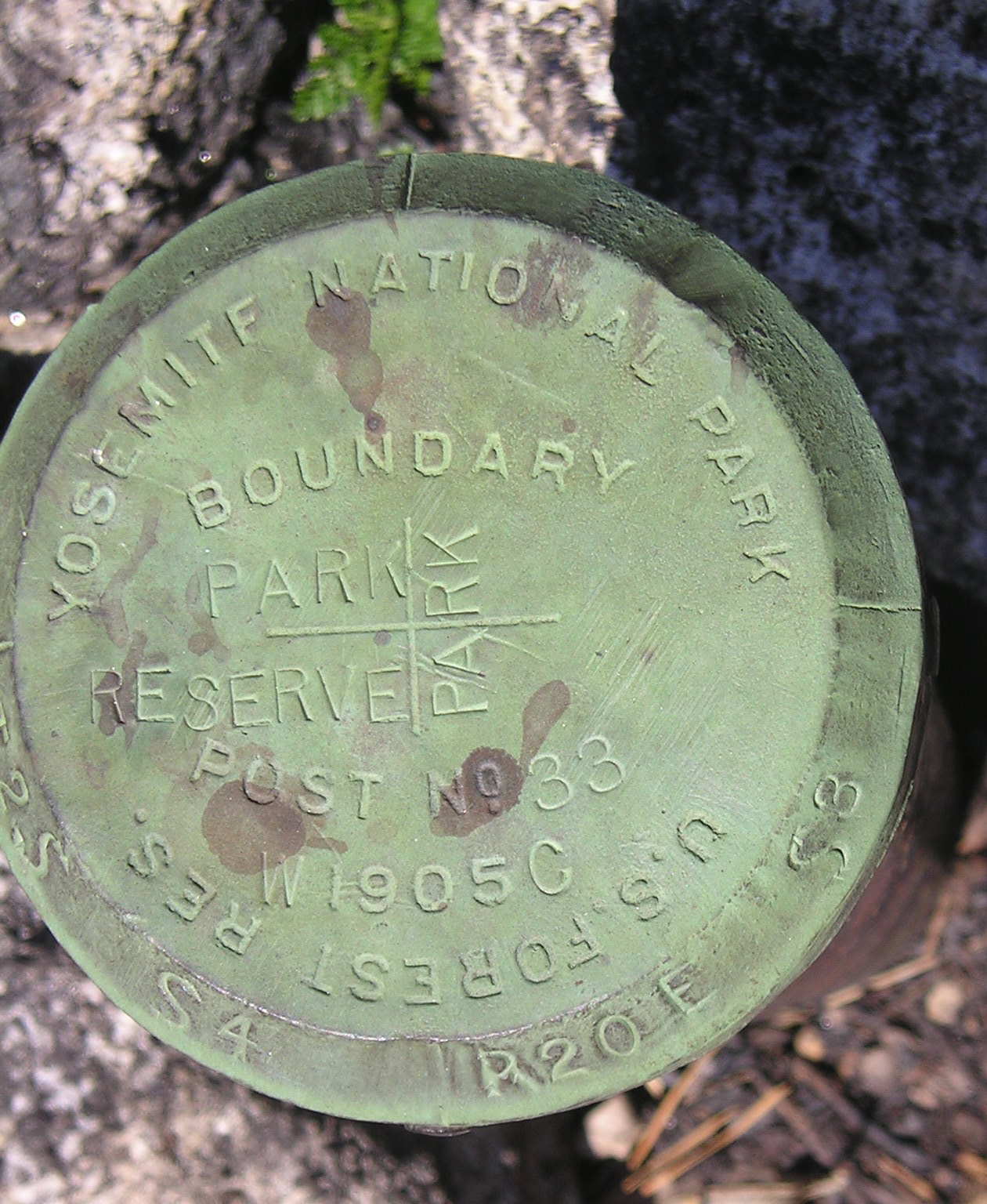
Surveyors do not map the earth in a void; they anchor their measurements to physical reality using monuments. Monuments are fixed objects used to establish boundaries and corners in a metes and bounds survey. Survey monuments can be natural objects like trees, boulders, or rivers, or they can be artificial objects like iron pins driven into the earth.
Legal Precedence Rule: Human measurement is prone to error, but physical reality is undeniable. If a discrepancy exists between recorded distances and physical monuments, the physical monuments take legal precedence. If the deed says a property line extends 100 feet to an ancient oak tree, but a modern surveyor measures the tree at 103 feet, the boundary legally extends to the tree.
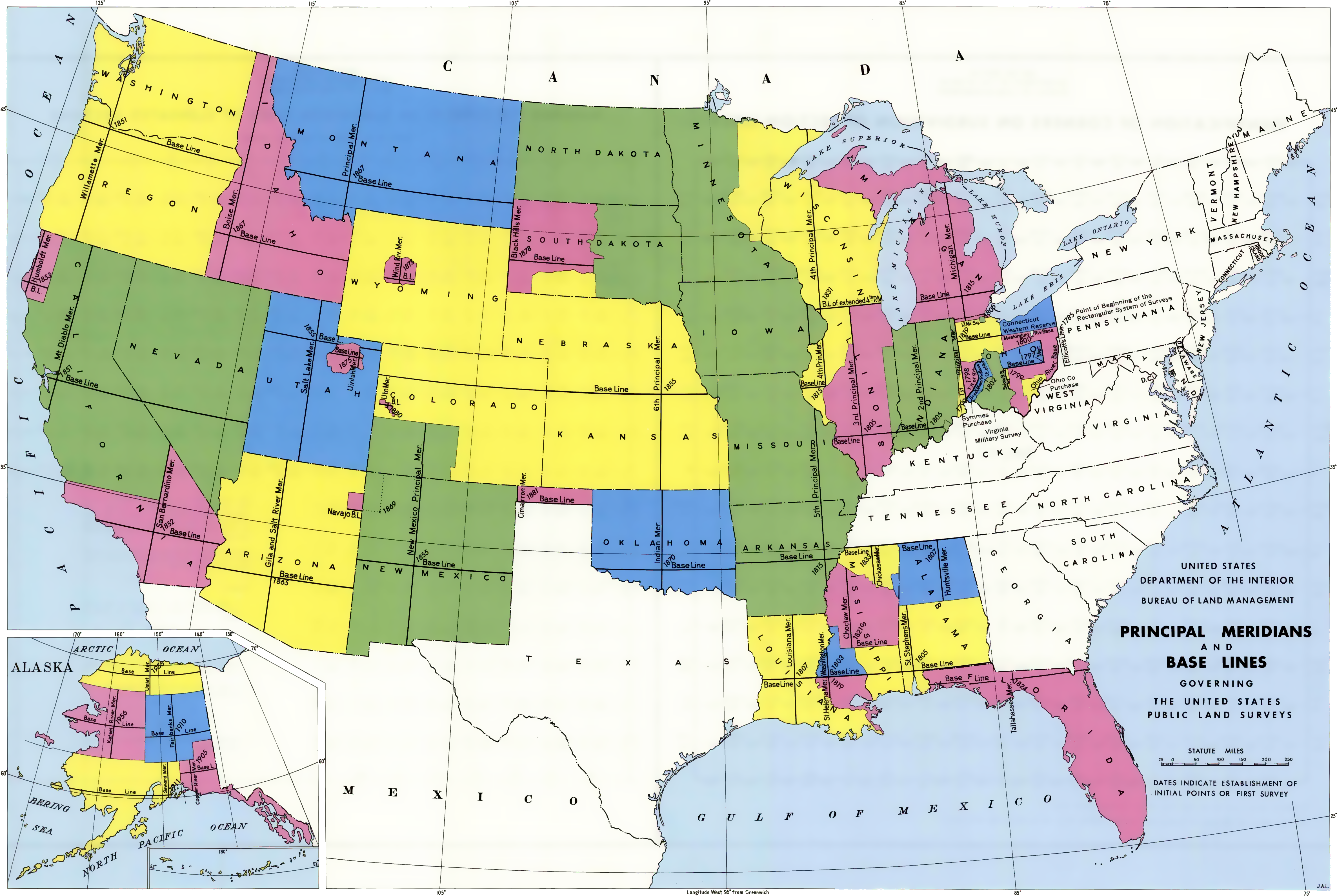
By 1785, the United States was rapidly expanding westward, creating an urgent need to map, divide, and privatize vast tracts of wilderness. The federal government established the rectangular survey system in 1785 to facilitate the sale of public lands. Today, this is also widely known as the government survey system.
Rather than relying on isolated trees and iron pins, the government survey system is based on intersecting sets of lines that form a mathematical grid spanning across the country.
The Macro Grid: Meridians and Base Lines
The foundation of this system rests on two primary axes:
- Principal meridians are the main north-south reference lines in the government survey system.
- Base lines are the main east-west reference lines.
From these starting axes, the grid is subdivided by parallel lines running every six miles.
- Range lines run north-south, parallel to the principal meridian. They are spaced exactly six miles apart. The vertical strips of land formed between two adjacent range lines are called ranges.
- Township lines run east-west, parallel to the base line. They are also spaced exactly six miles apart. The horizontal strips of land formed between two adjacent township lines are called tiers.
Because the earth is a sphere, parallel vertical lines drawn on a map will inevitably converge as they travel toward the poles. To maintain the uniformity of the grid, correction lines are utilized in the government survey system to compensate for the curvature of the earth.
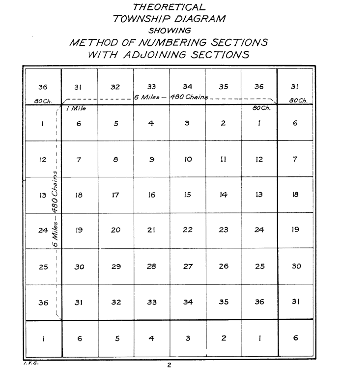
The Township and The Section
The intersection of range lines and township lines forms a township, which is a square geographical unit. A standard township measures exactly six miles on each side. Therefore, a standard township contains exactly 36 square miles.
To make the land easily salable to farmers and settlers, each standard township is divided into 36 individual sections.
- A standard section measures exactly one mile square.
- A standard section contains exactly 640 acres.
- (By definition, one square mile of land contains exactly 640 acres).
The numbering of these 36 sections follows a rigid, snake-like pattern (boustrophedon):
- Section 1 is located in the extreme northeast corner of a standard township.
- Section numbers in a township proceed sequentially west from Section 1 to Section 6.
- Section 7 is located directly south of Section 6 within a standard township.
- Section numbering proceeds sequentially east from Section 7 to Section 12.
- This back-and-forth pattern continues until Section 36 is located in the extreme southeast corner of a standard township.
Historical Fact: As you examine a township map, look at the very center. Section 16 of a standard township was historically reserved to generate funding for public school purposes, as its central location made it accessible to all families in the township.
Rectangular Survey Math for Real Estate Transactions
As a real estate professional, you must instantly translate fractions of a section into marketable acres. A rectangular survey property description is traditionally read backward from the largest defined area to the smallest defined parcel.
Imagine a deed describing property as: The NW 1/4 of the SE 1/4 of Section 10. To read this, you start at Section 10 (640 acres), locate its Southeast quarter, and then zoom into the Northwest quarter of that specific quadrant.
Calculating Acreage: To calculate the acreage of a parcel described by fractions in a rectangular survey, divide 640 by the denominators of all the fractions.
Let's calculate the acreage for The NW 1/4 of the SE 1/4 of Section 10:
- 640÷4=160 (A single quarter-section of land contains exactly 160 acres).
- 160÷4=40 (A quarter of a quarter-section of land contains exactly 40 acres).
- This parcel is 40 acres.
The Crucial "AND" Rule: In legal descriptions, the word "and" separates distinct land parcels. When the word 'and' appears in a rectangular survey description, the acreage of each separated segment must be calculated individually and added together.
Example: Calculate the acreage of The N 1/2 of the SW 1/4 AND the SE 1/4 of Section 8.
- Calculate the first parcel: 640÷4÷2=80 acres.
- Calculate the second parcel: 640÷4=160 acres.
- Add them together: 80+160=240 total acres.
If your client is purchasing this 240-acre property at $5,000 per acre, the transaction value is $1,200,000.
The Golden Number: You will frequently need to convert acreage to square footage. Memorize this permanently: One acre of land contains exactly 43,560 square feet.

While the government survey system is perfect for vast agricultural tracts, it breaks down when mapping densely populated neighborhoods. The lot and block method of legal description is primarily used for subdivided urban and suburban properties. It is also officially known as the recorded plat method.
A lot and block description always relies on a prior metes and bounds survey to define the outer perimeter of the entire subdivision. Once the surveyor maps the master perimeter of the neighborhood, the lot and block system divides that large parcel of land into numbered blocks and individual lots.
- A block refers to a contiguous group of lots bounded by streets or other physical features in a subdivision.
- A lot refers to a single parcel of land designated for individual residential or commercial use within a subdivision.
This intricate subdivision layout is documented on a plat map, a detailed survey map showing the divisions of a subdivision. Because local governments must regulate zoning, street widths, and utility access, a plat map must be approved by local authorities before being officially recorded. Once approved, the subdivision plat map is recorded in the public records of the county where the land is located.

When you sell a suburban house, the deed rarely mentions degrees or sections. It simply reads: Lot 14, Block B, Sunny Acres Subdivision, as recorded in Plat Book 42, Page 112, of the public records of Washington County.
Real estate is not just a flat, two-dimensional surface; it encompasses geometry from the center of the earth upward into the sky. Vertical land descriptions are used to legally define physical boundaries on a vertical axis.
Vertical descriptions allow us to:
- Legally define air rights above a property (e.g., selling the space above an active train station to construct a high-rise).
- Legally define subsurface rights below a property (e.g., mineral or transit rights beneath the topsoil).
- Legally define the physical boundaries of condominium units.
Condominiums are essentially cubes of owned air suspended in physical space. Vertical land descriptions are essential for defining the physical boundaries of condominium units, distinguishing exactly where unit 4B ends and unit 5B begins.

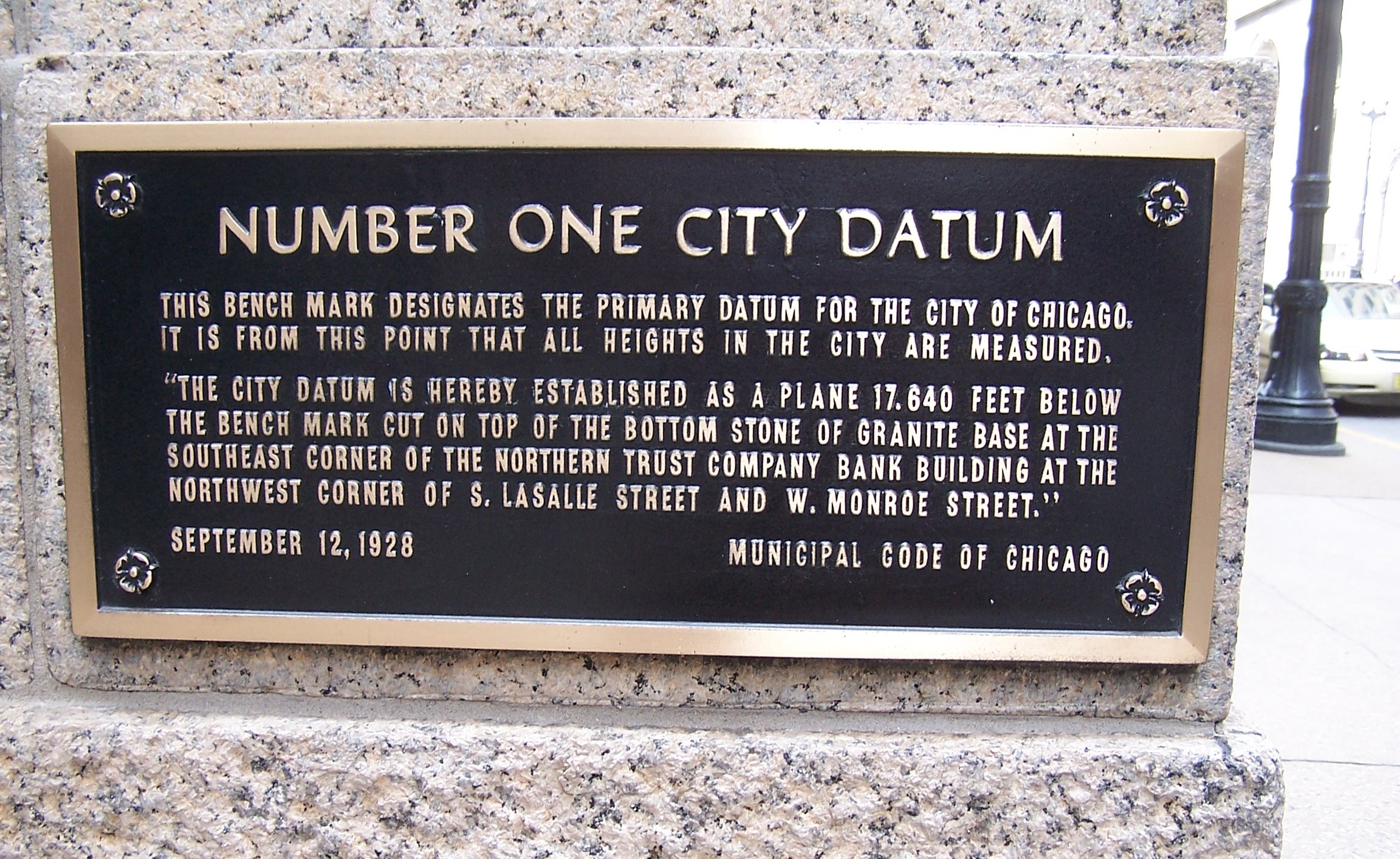
Datums and Benchmarks
To measure elevation accurately, surveyors need an absolute starting point. A datum is a standard reference point, line, or surface used by surveyors to measure vertical elevations. For decades, the National Geodetic Vertical Datum of 1929 (NGVD 29) has served as a commonly referenced official datum in the United States, pegging "zero elevation" to the mean sea level.
Because surveyors cannot travel to the ocean every time they measure a local property, they rely on localized markers. Benchmarks are permanent reference marks placed by surveyors (often brass plates set in concrete or stone) to indicate specific official elevations in relation to the datum. When a surveyor calculates the exact elevation of the 14th floor of a new condominium, they calibrate their instruments against the nearest official benchmark.