Physical Processes and Climate Patterns
Not sure you’re ready?
Take the ~3-minute readiness diagnostic and see where you stand.
History is written on a canvas stretched across a relentless, dynamic geologic and atmospheric engine. Every civilization you will teach—from the Sumerians in the Mesopotamian floodplains to the pioneers traversing the American Midwest—had their destinies shaped by the invisible mechanics of heat transfer, tectonic drift, and atmospheric pressure. To teach social studies effectively, you cannot merely recite what happened; you must explain where and why it happened there. Human geography is the story of how our species negotiates the physical processes of the Earth.
When you stand in front of your classroom, you need your students to understand that Earth’s geography is not a static map. It is a constantly moving system of interconnected parts. Let us dismantle this machine and examine the gears.
The most fundamental distinction you must clarify for your students is the difference between what happens outside today and what happens over a lifetime.
Weather describes the short-term atmospheric conditions of a specific location at a specific time. It is the thunderstorm that cancels a baseball game or the sudden freeze that damages a Florida orange crop. Climate, on the other hand, represents the long-term average of weather patterns in a specific region.
If weather is a single roll of the dice, climate is the statistical probability of the entire casino.
The 30-Year Rule: The World Meteorological Organization defines the standard period for measuring a region's climate as exactly thirty years. This provides a statistically significant baseline to distinguish true climate from random annual variations.
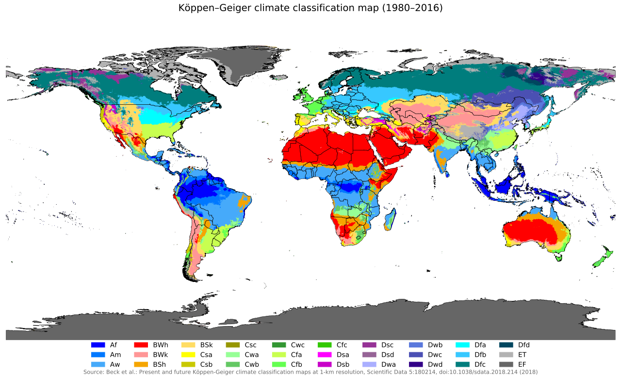
To make sense of global climates, geographers rely on the Köppen climate classification system, which categorizes global climates based on average monthly temperatures and precipitation. This system allows us to define extreme environments logically:
- Tropical rainforest climates experience consistently high temperatures and heavy rainfall year-round.
- Desert climates generally receive less than 10 inches of precipitation annually.
Why is a tropical rainforest sweltering while the tundra is frozen? The distribution of Earth's heat relies on three primary variables: latitude, elevation, and ocean currents.
1. Latitude and Solar Radiation
Latitude measures the distance north or south of the equator in degrees. Because the Earth is a sphere, higher latitudes receive less direct solar radiation than regions located near the equator. The energy from the sun strikes the poles at a shallow, glancing angle, spreading out over a larger area. Consequently, average atmospheric temperatures generally decrease as latitude increases.
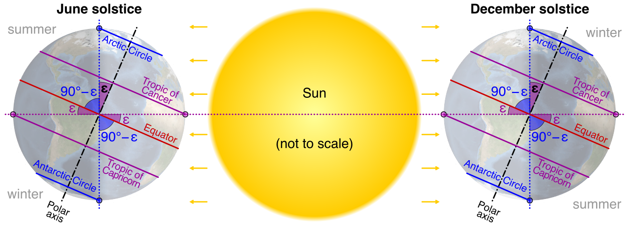
However, the Earth does not sit perfectly upright. The Earth's axial tilt causes seasonal climate variations at middle and high latitudes. As the Earth orbits the sun, different hemispheres lean toward or away from the solar radiation, driving the rhythmic cycle of seasons that dictated the agricultural calendars of every ancient civilization.
2. Elevation and the Lapse Rate
If latitude dictates the horizontal distribution of heat, elevation—the height of a geographic location above sea level—dictates the vertical distribution.
As you climb a mountain, the air pressure drops. The expanding air cools, meaning atmospheric temperature decreases as elevation increases. This is highly predictable:
The Normal Environmental Lapse Rate: Atmospheric temperatures dictate a temperature drop of about 3.5 degrees Fahrenheit per 1,000 feet of elevation.
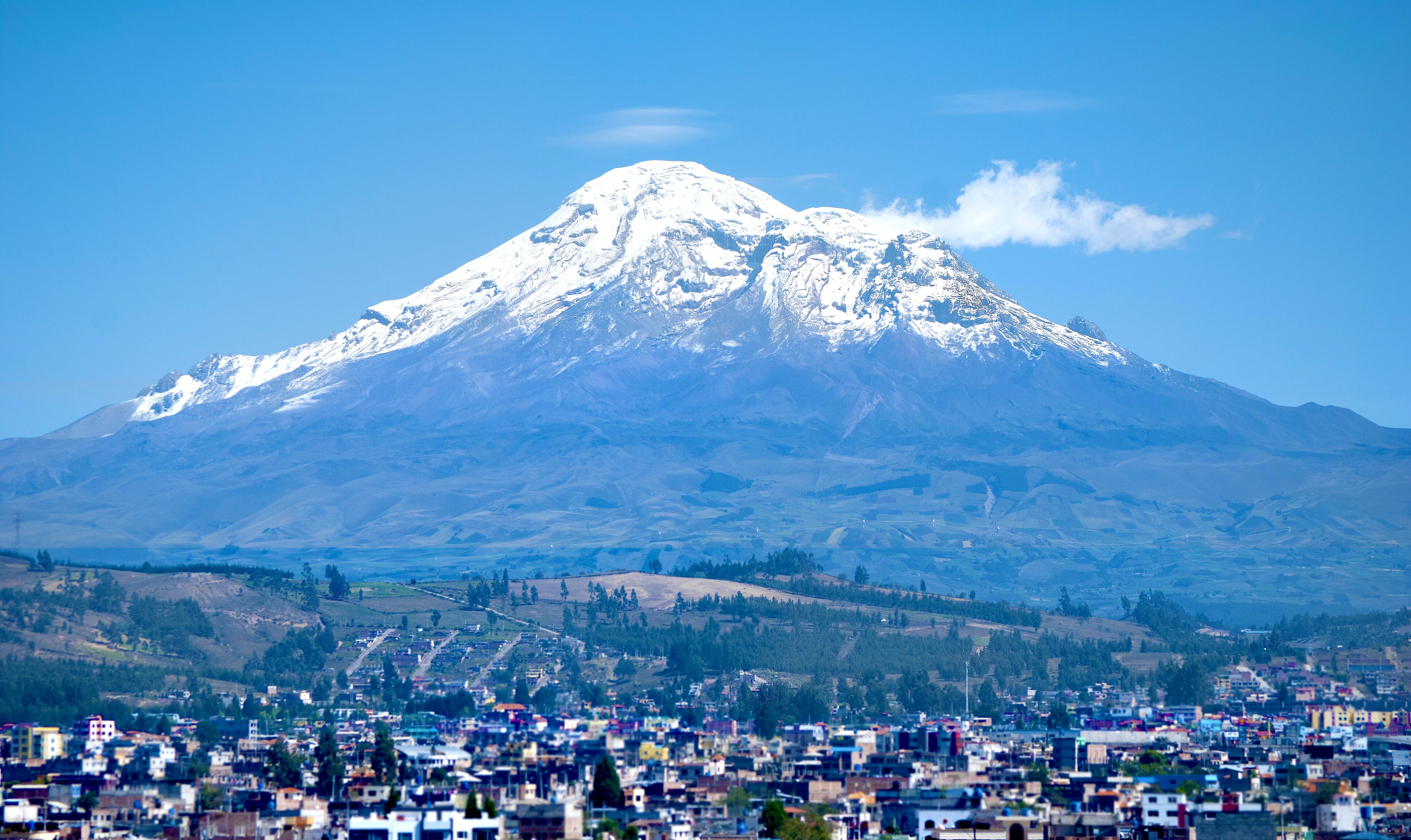
This explains why you can stand in a sweltering valley in Ecuador (on the equator) and look up to see snow-capped Andean peaks.
3. The Great Conveyor Belts: Ocean Currents
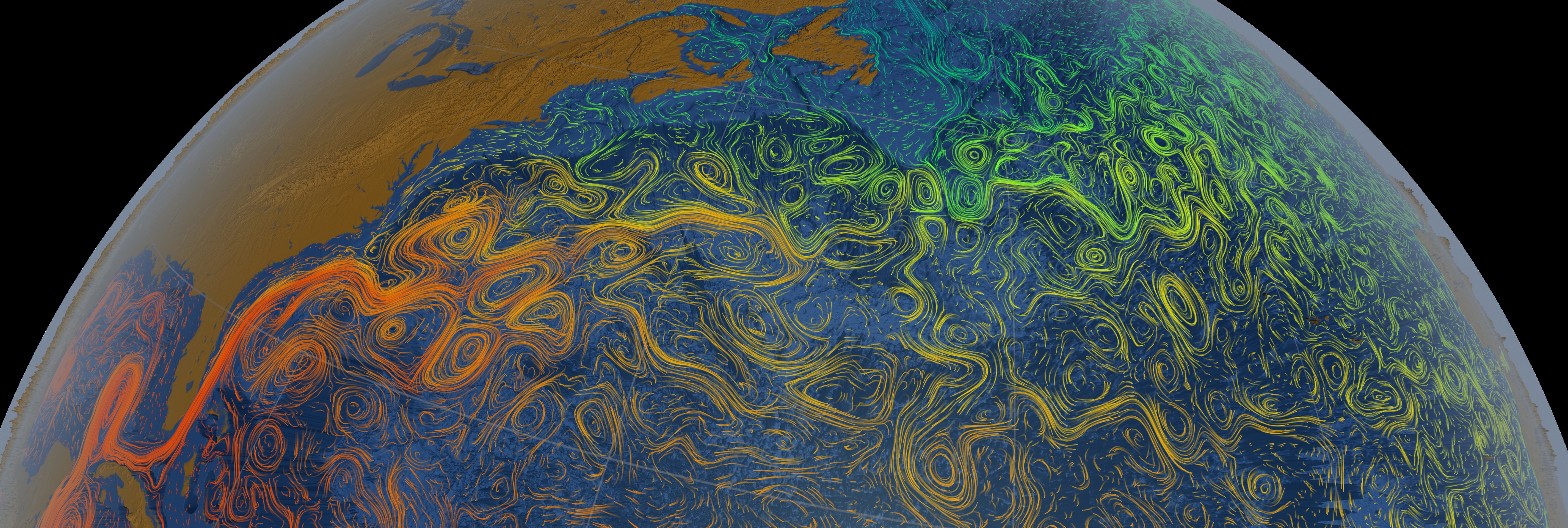
Water holds heat far better than air. Ocean currents act as a massive global circulatory system, moving global heat by circulating warm water from the equator toward the poles, while simultaneously circulating cold water from the poles toward the equator.
This movement is subjected to the Coriolis effect, a phenomenon caused by Earth's rotation that deflects moving objects. The Coriolis effect deflects ocean currents to the right in the Northern Hemisphere and to the left in the Southern Hemisphere.
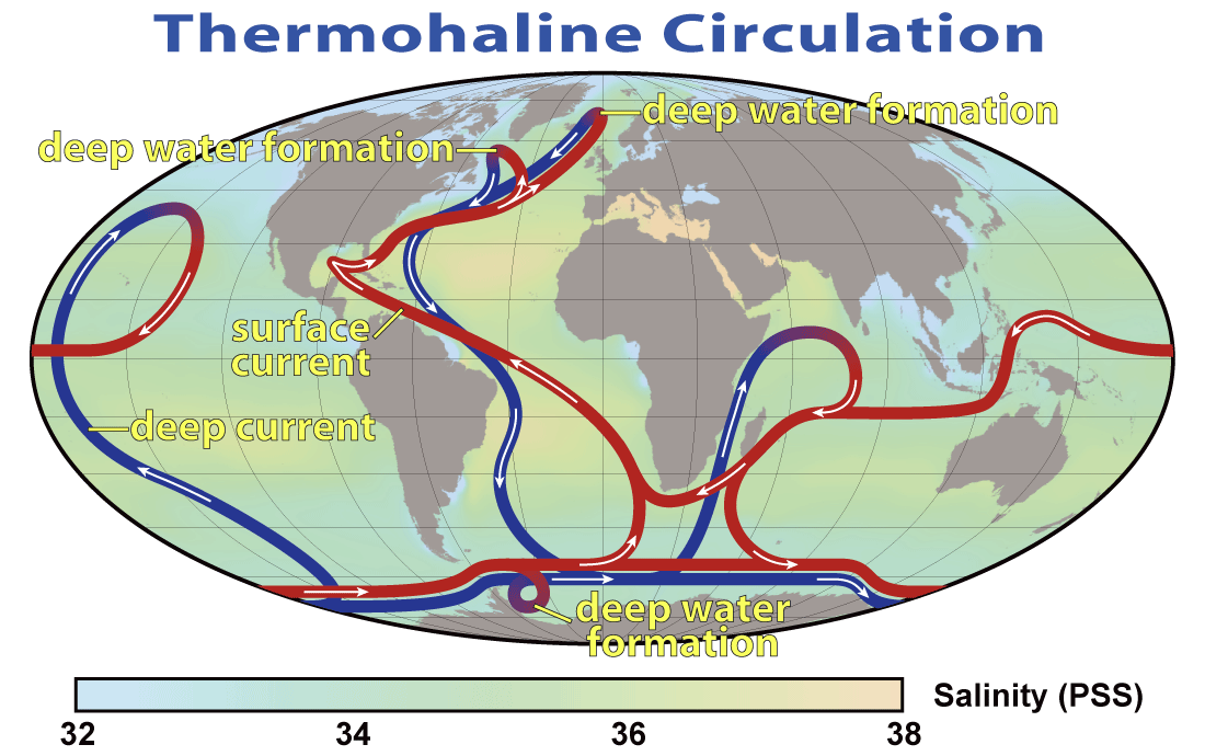
Consider how this shapes history:
- The Gulf Stream is a warm Atlantic ocean current. Pulled northward, the warm waters of the Gulf Stream moderate the climate of Western Europe. Without it, Great Britain would have a freezing, sub-arctic climate similar to parts of Canada at the exact same latitude.
- Conversely, the California Current brings cold water from the northern Pacific Ocean south along the western coast of North America, keeping summer temperatures in San Francisco famously chilly.
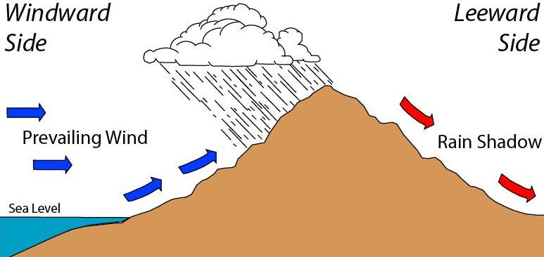
When moving air encounters landforms, the results define regional ecosystems. Mountain ranges act as atmospheric speed bumps, forcing moisture-laden air masses to rise and cool.
This process, known as orographic lifting, causes precipitation to fall heavily on the windward side of a mountain range (the side facing the wind). Once the air passes over the peak, it has lost its moisture. As it descends, it warms, creating the rain shadow effect—dry, arid conditions on the leeward side of a mountain range. If your students ever ask why western Washington state is a lush green forest while eastern Washington is a brown desert, orographic lifting is the answer.
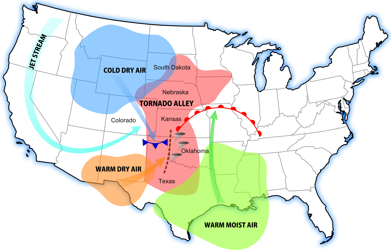
The Geography of Tornadoes
What happens when there are no mountains to block the air? Look at the North American continent. The physical geography of the central United States lacks east-west mountain barriers.
Because there is no topographic wall separating the Gulf of Mexico from the Arctic, the lack of east-west mountain barriers facilitates the frequent collision of contrasting air masses. Tornadoes form precisely when cold, dry air masses from Canada collide violently with warm, moist air masses from the Gulf. This unique geographic recipe created Tornado Alley, a region in the central United States with a spectacularly high frequency of tornadoes.
The Earth's surface is merely a cracked shell floating on a heated, shifting interior. Plate tectonics involves the movement of the Earth's lithosphere over the underlying mantle. Where these massive plates meet, geologic drama unfolds.
| Plate Boundary | Mechanism | Result |
|---|---|---|
| Convergent | Occur where two tectonic plates collide. | Creates towering mountain ranges (e.g., Himalayas) or deep ocean trenches. |
| Divergent | Occur where two tectonic plates move apart. | Creates new oceanic crust and mid-ocean ridges. |
| Transform | Occur where tectonic plates slide past one another laterally. | Creates severe fault lines (e.g., San Andreas Fault) known for earthquakes. |
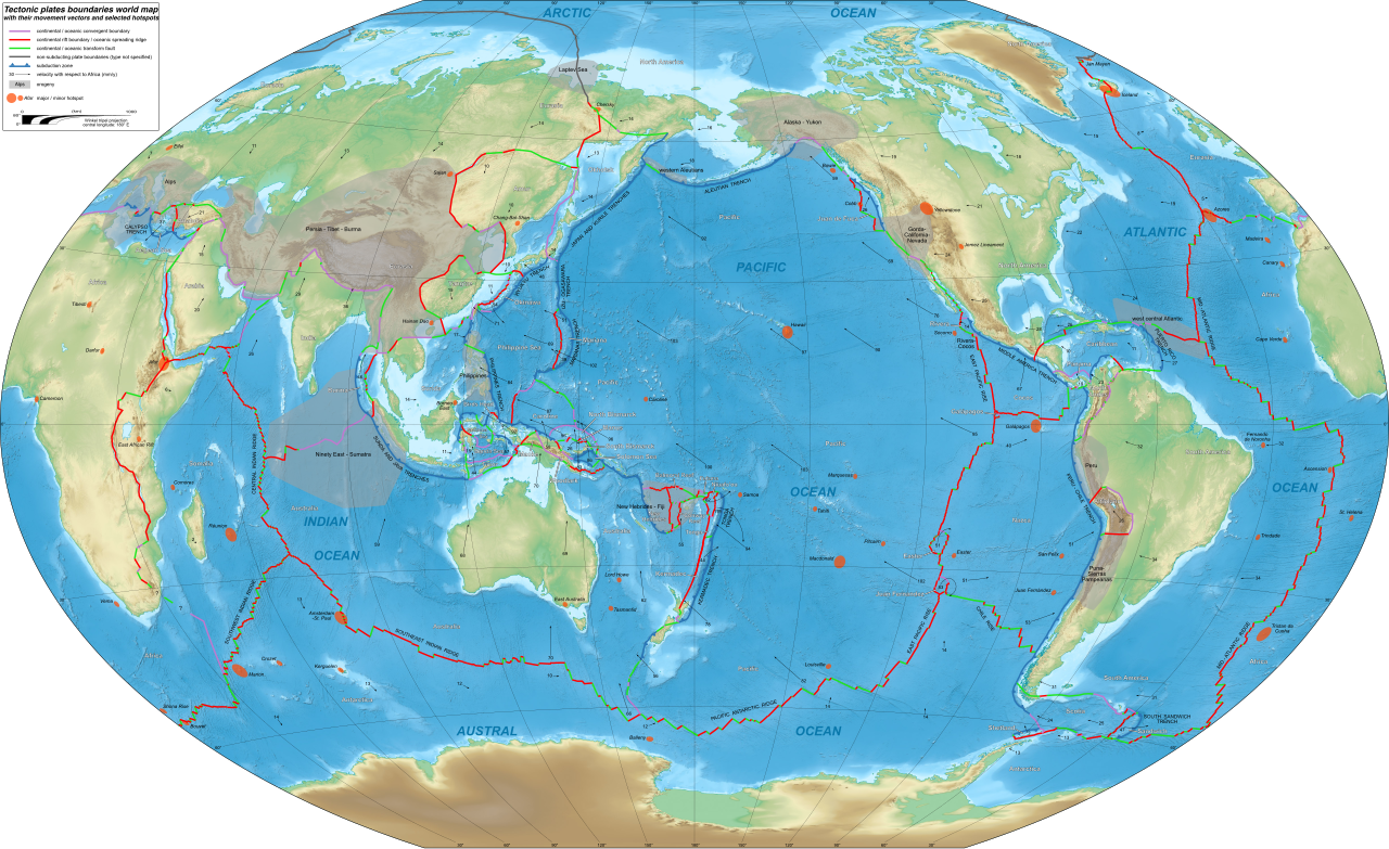
These movements are the primary engines for natural hazards. Earthquakes result from the sudden release of energy in the Earth's crust along fault lines. When an earthquake occurs underwater, the sudden jolt can trigger tsunamis by displacing large volumes of ocean water. When these massive waves reach shallow shores, tsunamis cause catastrophic coastal flooding and infrastructure destruction in human settlements.
Volcanoes offer another vital intersection of physical science and human history. Volcanic eruptions release ash, aerosols, and gases into the atmosphere. When a massive eruption occurs, it can inject millions of tons of sulfur dioxide into the stratosphere. These large-scale volcanic eruptions can temporarily lower global temperatures by reflecting solar radiation back into space. However, humanity often builds right on the flanks of these ticking time bombs. Why? Because over centuries, volcanic ash eventually produces highly fertile soil highly beneficial for agricultural societies.
Over time, these massive tectonic landforms are worn down by two relentless processes:
- Weathering: The physical or chemical breakdown of rocks and minerals directly at the Earth's surface.
- Erosion: The subsequent transport of those weathered materials by water, wind, or ice.
While tectonic hazards lurk beneath the surface, atmospheric hazards develop above the oceans.
Hurricanes (or typhoons/cyclones depending on the ocean) are massive engines of heat. They strictly form over warm tropical ocean waters, requiring ocean surface temperatures of at least 80 degrees Fahrenheit to develop. When they strike land, the high winds are terrifying, but the real killer is the water. A storm surge is a coastal flood of rising water commonly associated with tropical cyclones. Pushed by the storm's incredible wind pressure, storm surges cause the majority of coastal destruction and loss of life during hurricane events.
Global Oscillations: ENSO
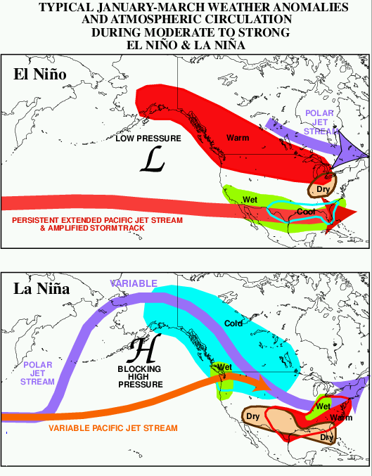
The oceans and the atmosphere are locked in a continuous, complex dance. The most impactful example of this is the El Niño-Southern Oscillation (ENSO), a periodic fluctuation in sea surface temperature across the equatorial Pacific Ocean.
This Pacific phenomenon drastically alters the weather in the United States:
- El Niño events typically bring increased rainfall and cooler temperatures to the southern United States.
- La Niña events flip the script, typically causing warmer and drier drought conditions in the southern United States.
The Lifeblood of Asia: Monsoons
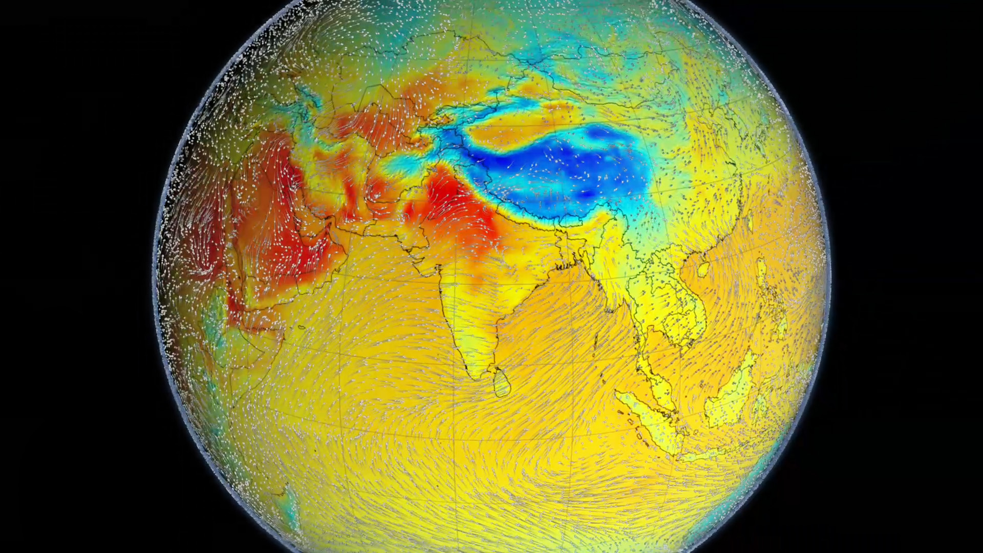
In parts of the world, predictable atmospheric shifts are the basis of survival. Monsoons are dramatic seasonal wind shifts that create distinct wet and dry seasons. During the summer, the Asian landmass heats up faster than the Indian Ocean, drawing in massive amounts of moist ocean air. South Asian agriculture heavily depends on these summer monsoon rains for crop irrigation. Without the monsoon, billion-person economies face famine.
This brings us to the ultimate synthesis for your social studies students: the human element. Geography is not destiny, but it is the strongest hand in the deck.
Consider where civilizations choose to lay their foundations. Human societies historically settle in river floodplains due to incredibly fertile soil (thanks to weathering, erosion, and sediment deposition upstream) and vital access to transportation networks. From the Nile to the Mississippi, rivers are the highways and grocery stores of antiquity.
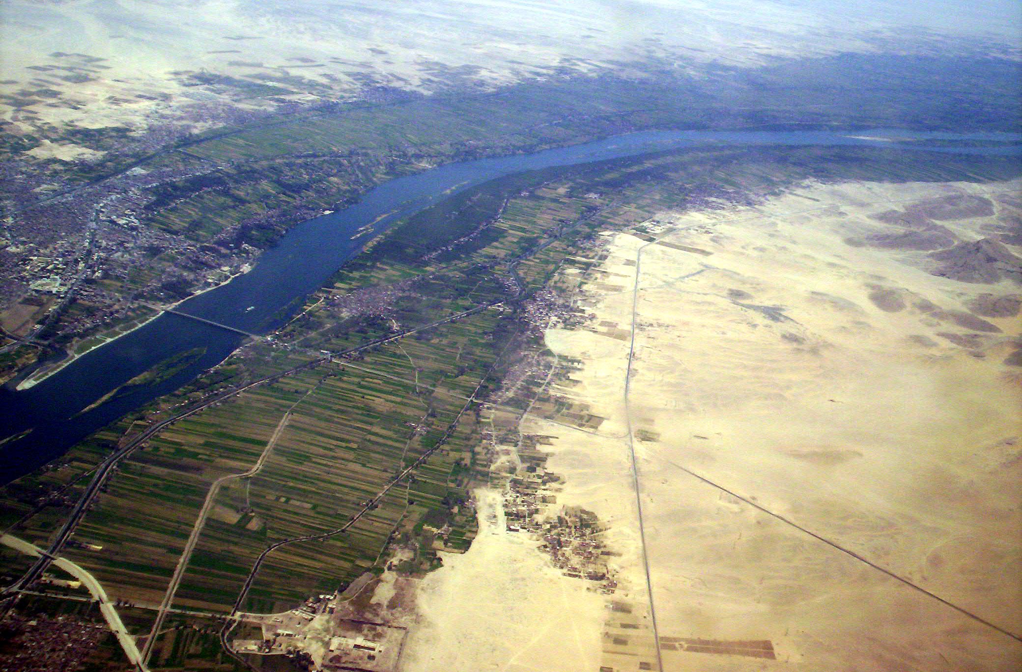
But Earth is uncompromising. Settlement in river floodplains exposes human populations to severe periodic flooding hazards. The story of human civilization is a constant negotiation with the planet—harnessing its life-giving ocean currents and fertile volcanic soils, while bracing against its hurricanes, tectonic ruptures, and climatic shifts. When you teach history, civics, or economics, you are teaching the ongoing results of that negotiation.